Introduction
 In 2018 the State Government released the Perth and Peel @ 3.5 Million strategy and the associated South Metropolitan Peel Sub-regional Planning Framework ('Planning Framework').
The intent of the Planning Framework is to plan for the future growth of the Perth metropolitan and Peel regions to accommodate a projected population of 3.5 million by 2050. The sub-regional framework is intended to provide guidance for:
- the preparation of amendments to the Metropolitan Region Scheme, the City of Rockingham Local Planning Scheme, the Local Planning Strategy, Structure Plans, and Activity Centre and Precinct structure plans; and
- The staging and sequencing of urban development to inform public investment in regional, community, social and service infrastructure.
The Planning Framework can be viewed on the Department of Planning, Lands and Heritageopens in a new windowopens in a new windowopens in a new window website.
The Planning Framework has confirmed the intended footprint for urban expansion within Karnup. The area shown for future urban development is identified to be delivered post 2031. The Karnup area has been identified as a future urban cell within strategic plans dating back to the 1980's.
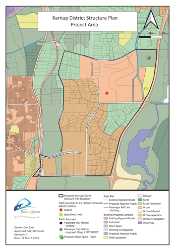
The Framework designated Karnup as 'Urban Expansion Area' to serve as a key urban growth corridor for the sub-region. The Framework identifies a number of key land uses within the District Structure Plan including:
- a new District Centre
- a Specialised Node as a strategic site for longer-term public uses, centrally located between Rockingham-Kwinana and Mandurah-Pinjarra, and providing for a range of regional public facilities which may include education, health and other future ancillary uses
- a 50 ha Regional Sporting Facility site
- a future railway station and transit orientated development on the Mandurah Railway Line, supported by a network of High Priority Transit Corridors and High Frequency Transit Corridors that will provide public transport connections betweens activity centres, population catchments, rail stations and local bus services, and
- various changes to the regional transport hierarchy.
The Planning Framework requires the City to prepare a District Structure Plan, for the approval of the State Government, in advance of rezoning and subdivision within the area.
The City is committed to progressing preparation of the District Structure Plan. In February 2023, Council appointed a Consultant Team, led by CDP Town Planning and Urban Design, to undertake the necessary technical investigations, and to prepare the District Structure Plan, in close liaison with the City.
The consultant team includes town planners, urban designers, civil engineers, traffic engineers, hydrologists, retail economists, environmental scientists, landscape architects, bushfire consultants, and community engagement specialists.
District Structure Plan area
The Karnup District Structure Plan area is approximately 2000ha in land area, extending from Stakehill Road in the north to Paganoni Road in the south, and from Mandurah Road/Fletcher Road/Stakehill Road and Nairn Drive to the west, to Baldivis Road/Stakehill Road and Kwinana Freeway to the east.

It includes land already zoned 'Urban Deferred' and owned by DevelopmentWA on the southern side of Stakehill Road, along with 130ha of land reserved 'Parks and Recreation'. The area comprises a large proportion of fragmented landholdings. The balance land is predominantly zoned 'Rural' and 'Special Rural'.
Why prepare a District Structure Plan?
A District Structure Plan is a high level strategic plan which will help guide where future land uses like housing, shops and open space are located. It will also help coordinate the provision of future services and infrastructure like major roads, water reticulation and wastewater infrastructure.
The need to prepare a District Structure Plan is outlined within the Planning Frameworkopens in a new windowopens in a new windowopens in a new window. It is required to be prepared by local government in collaboration with Department of Planning, Lands and Heritage (DPLH) for the approval of the State Government, as a precursor to rezoning and development.
The Karnup District Structure Plan will identify:
- future residential precincts;
- areas to be protected, such as bushland, streams and other wetlands;
- the location of future primary and high schools;
- the location of future hospitals and other community facilities;
- areas to be set aside for shopping centres;
- commercial and employment areas;
- major sporting ovals and facilities;
- the location of major roads and public transport routes; and
- connections and integration with the planning Karnup train station being progressed by the State Government as part of METRONET.
What is involved in preparing a District Structure Plan?
The process of preparing the District Structure Plan is quite long and is expected to take up to three years. The projects will be undertaken over five phases:
- Phase 1: Preparation of the Background Report and Mosquito Assessment and Management Plan (further discussion on this phase is provided below).
- Phase 2: Preparation of Community Outcomes and Vision Report.
- Phase 3: Preparation of Draft District Structure Plan (inclusive of all supporting documentation).
- Phase 4: Undertaking of Community Consultation of Draft District Structure Plan.
- Phase 5: Final District Structure Plan.
Phase 1 is complete. Phase 2 has commenced, and is expected to conclude in late 2024. Phase 3 is expected to commence early 2025.
The District Structure Plan will be informed by a number of studies and assessments including:
- Mosquito Risk Assessment and Management Plan (MRAMP)
- Environmental Assessment Report (including flora, fauna, wetland assessment, indigenous heritage, spring survey and black cockatoo habitat assessment)
- Community Outcomes and Vision Report
- Engineering Servicing Plan
- District Water Management Strategy
- Bulk Earthworks Strategy
- Development Contribution Arrangement Strategy
- Bushfire Management Plan
- Community Engagement Strategy and process
- Landscape Masterplan
- Transport Impact Assessment (including rail noise and vibration considerations)
- District Economic, Retail and Employment Strategy
It will also be informed by a range of adopted and draft strategies, policies and studies prepared by State Government, and by the City, which provide context for the planning of the area, including those prepared recently to support the Local Planning Strategy.
The City is involved in undertaking mosquito monitoring which will inform the Mosquito Risk Assessment and Management Plan; and in preparing a Community Infrastructure Plan (CIP), which will help inform the District Structure Plan.
Once the District Structure Plan has been prepared, advertised for public comment and adopted by the City, it will be considered and approved by the Western Australian Planning Commission (WAPC).
Following approval to the District Structure Plan, land will be subject to Metropolitan Region Scheme and Local Planning Scheme Amendments, Structure Plans and other processes, prior to subdivision. These processes could take up to 10 years (or more) to be complete.
How to get involved
Following advice from the Western Australian Planning Commission and Council’s support at its Ordinary Council meeting held on 28 May 2024, the Karnup District Structure Plan (KDSP) project is now in the stakeholder engagement, visioning and design phase.
In early August we held a series of Consultation Workshops where we invited members of the community to participate in this phase which will guide zoning, land use, and development within Karnup. Feedback received during these engagement sessions will be used to guide the locations for future housing, shops, schools, and open spaces. The workshops were facilitated by City Planners and Project Team experts and we thank everyone who was able to make it along to share your insights and ideas, and influence the future development of Karnup.
Here’s some other ways to engage.
Other projects currently being advertised for public comment in the Karnup area
While the City is running it's own stakeholder engagement in preparation of the draft DSP there are also many external opportunities for engagement on projects relating to Karnup. When an item is listed or open for public comment it will be listed here.