The following documents are discussed in the above documentation and may be of interest to you:
Activity Centre Plan
State Planning Policy 4.2 - Activity Centres for Perth and Peel (SPP 4.2) requires the City of Rockingham to prepare and maintain an endorsed Activity Centre Structure Plan to guide development within the Rockingham Strategic Centre.
Consistent with the regional context of the Rockingham Activity Centre, and in satisfaction of the requirements of SPP 4.2, we completed a major two-stage review and expansion of our 1995 Development Policy Plan for the Strategic Centre.
The purpose of the review was to update the existing plans for the Strategic Centre and to prepare a contemporary overall Structure Plan to guide the future development of public and private property within the centre.
Key issues addressed during the review process were:
- an update of the existing 1995 Development Policy Plan (DPP)
- investigation of the Ministerial Enquiry by Design (Ebd) Outcomes
- review road hierarchy and update traffic and parking studies
- review land uses in City Centre
- establish Murdoch University land requirements
- identify Transit Oriented Development (TOD) opportunities
- identify infrastructure requirements within the City Centre
- identify potential sites for a proposed Contemporary and Performing Arts Complex
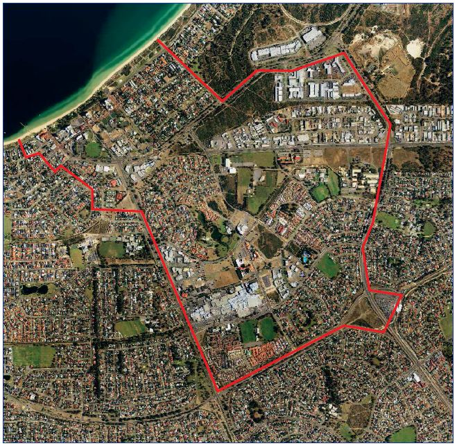
The planning envelope covers nearly 600 hectares stretching from the Rockingham Train Station to Rockingham Beach and includes the City Centre, the Rockingham Waterfront Village, the joint tertiary education campuses and associated service commercial, residential and recreation areas.

Figure 1: Rockingham Strategic Centre Planning Envelope
The Centre Plan will accommodate a sophisticated coastal Activity Centre servicing an anticipated population of 275,000 people from the Rockingham and Kwinana areas.
The vision is for a modern, distinctly coastal centre offering a wide range of mixed uses including retail, commercial, office, civic, residential, education, cultural and recreation within an accessible and highly inter-connected, urban-scaled townscape, comprising a major Activity Centre and related urban villages based on 'main street' principles.
Development will be defined and characterised by:
- medium to high density development based on activated 'main street' principles.
- a configuration of generally contiguous street front buildings and a mix of uses that generate high levels of pedestrian activity and a sense of vitality.
- a street-based transit system, with closely spaced stops.
- a permeable network of streets, laneways, arcades and public spaces that provide high quality linkages, particularly for pedestrians, to centre activities.
- an identifiable City Centre hub to provide major CBD functions.
- connected village precincts between the City Centre and Rockingham Beach along the route of the transit system.
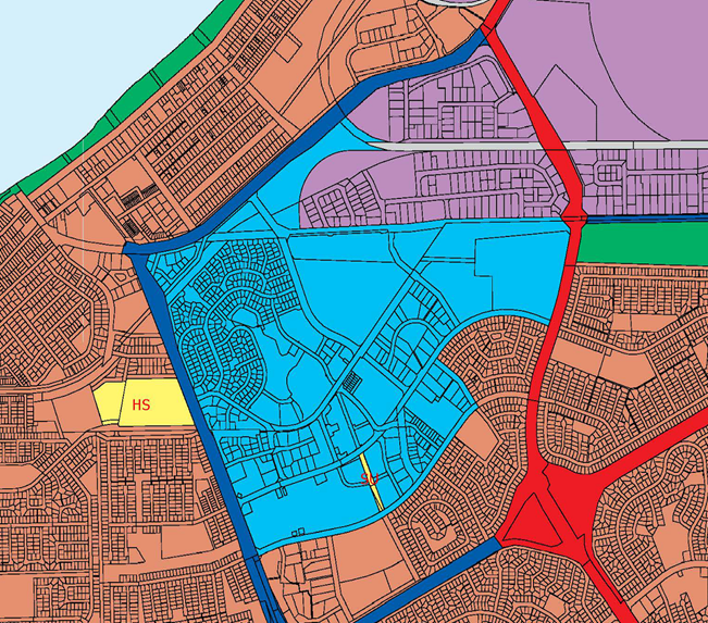
In 1996, the WAPC endorsed MRS Amendment No.967/33 which changed certain zones and reservation under the Metropolitan Region Scheme and included additional land within the City of Rockingham Central City Area Zone.

Figure 2: Central City Area Zone
Project background
The planning and development of the Strategic Metropolitan Centre is guided by the City Centre Development Policy Plan (DPP) which was originally incorporated into the Town Planning Scheme in 1995. The DPP was prepared to reflect the principles of orderly and proper planning based on a 'main street' town centre with mixed use, street front development framing an activated public domain in the City Centre.
The review of the DPP commenced in late 2006, following the completion of a Ministerial Enquiry by Design process into the expansion of the shopping centre.
With continuing growth in the region and the construction of the City Centre Transit System, a broader and more comprehensive Centre Plan was required to provide a long term vision and an integrated planning framework for development of the area.
Stage 1
Stage 1 of the review was adopted in February 2008 with the completion of an overall Framework Plan which illustrated how development could be arranged across the Centre. The Plan provided for a transit oriented land use pattern with greatly improved access and connectivity.
Particular emphasis was given to improved north-south connectivity. Importantly, the plan made the local transit system the focus of an intensified corridor of mixed use development between the City Centre, education campuses and the beachfront.
The plan focused on areas where there is the greatest potential and priority for integrated Transit Oriented Development, including land in the City Centre, Waterfront Village and along the City Centre Transit System.
Stage 2
Stage 2 of the review was completed in 2009 and contained general guidelines (Sector Briefs) for the City Centre, Waterfront Village, two proposed 'Smart Villages' and related residential areas and more detailed Precinct and Sub-Precinct guidelines to accompany the updated City Centre Indicative Development Plan (IDP).
An extensive public consultation program was undertaken, including static displays, public exhibition sessions and detailed briefings to government agencies and key stakeholders.
In September 2009, Council adopted the Stage 2 Reports as the Final Strategic Planning Reports, subject to minor modifications to accommodate issues raised during the consultation phase. In November 2009, the WAPC endorsed the Stage 2 Reports as per SPP 4.2 Activity Centre Plan to guide the future development of the City Centre.
In February 2010, Council considered reports which dealt with the next phase which included the conversion of the Centre Plan Reports into a Town Planning Scheme framework, a DPP for the City Centre Sector and zoning amendments to the Metropolitan Region Scheme.
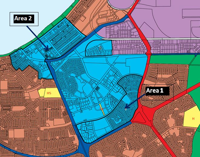
In accordance with the City's ongoing responsibilities to implement the planning framework of the RSMC, the WAPC considered a proposal to integrate two additional areas within the current boundary of the Central City Area Zone and rezone Areas 1 and 2 from Urban Zone to Central City Area Zone under the Metropolitan Region Scheme. The proposal was endorsed by the WAPC in February 2016.

Figure 3: Central City Area Zones - Areas 1 and 2
Rockingham City Centre Transit Study Advocacy Document
For some time now we've been working towards securing funding commitment towards the construction of a fixed route transit system, known as the 'Rockingham City Centre Transit System' (RCCTS).
The approved route of the RCCTS is via a shared and partially dedicated transport corridor which starts and ends at the Rockingham Train Station, taking in the City Centre and Rockingham beachfront.
The 'City Centre Transit System' document seeks to promote Rockingham by demonstrating the relationship between the approved planning framework and the transit route. It shows how public and private sector investment in construction projects could result in economic benefits, employment opportunities and social benefits for the City's residents.
More information on the planning framework and RCCTS can be found by viewing the planning policies listed in the download section.