The City of Rockingham is located in Perth's outer southern suburbs, about 40 kilometres south-west of the Perth CBD. The City of Rockingham is bounded by the City of Kwinana in the north, the Serpentine-Jarrahdale Shire in the east, the Shire of Murray and the City of Mandurah in the south and the Indian Ocean in the west.
The City of Rockingham is a rapidly developing residential area, with substantial industrial and commercial areas. It is the closest local government area to the Royal Australian Navy’s largest base, HMAS Stirling, on nearby Garden Island.
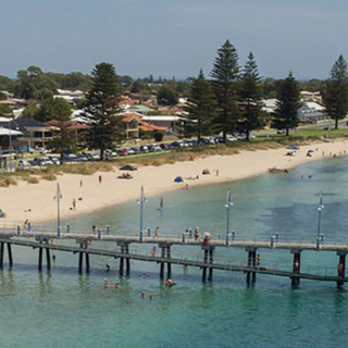
The City encompasses a total land area of approximately 260 square kilometres, including significant areas of coastline and parkland. With 37 km of breathtaking coastline, the area is known for its pristine beaches, nearby Penguin Island, dolphins and seals frequenting the area, and adventure experiences.
Find us
Rockingham
Suburbs in the City of Rockingham
- Baldivis
- Cooloongup
- East Rockingham
- Garden Island
- Golden Bay
- Hillman
- Karnup
- Keralup
- Peron
- Port Kennedy
- Rockingham
- Safety Bay
- Secret Harbour
- Shoalwater
- Singleton
- Waikiki
- Warnbro
History
Rockingham is named after the ship Rockingham which brought settlers to the colony and ran aground on the beach in Cockburn Sound in 1830. Visit our Heritage page to read more about our history and our heritage strategy.
Originally constituted as a Road Board on 21 May 1897, Rockingham became the Shire of Rockingham on 1 July 1961, and finally achieved City status on 12 November 1988. The criteria for becoming a City included having a population of more than 30,000, and a revenue of $200,000 sustained for three years. The district also had to be clearly distinguishable as a centre of population with sufficient residential, commercial and industrial centres.
As a comparison, the City is now designated as one of Perth's Strategic Metropolitan Centres and has a population of around 160,000 and an operating revenue of more than $156 million. Rockingham and surrounds is becoming an increasingly popular place to live and work, where residents place a high value on the relaxed coastal lifestyle that Rockingham offers.
The following information is a summary of the origins of the 16 suburb names in the City of Rockingham. Information obtained from Landgate.
Baldivis
This suburb was one of the State Government's Group Settlement schemes which was implemented in the 1920s to alleviate unemployment. A school building was completed and was given the name 'Baldivis' - a name coined by local settlers after three ships that brought them to WA in 1922, the 'Balranald', the 'Diogenes' and the 'Jervis Bay'. On 17 November 1972, the Shire of Rockingham requested that a Rural Ward of the Shire east of Mandurah Road be named 'Baldivis', being the name of the telephone exchange and school in the area. This was approved on 15 January 1973. ‘Baldivis’ was approved as a Postal Locality name on 20 November 1973 and Gazetted on 5 April 1974. Locality boundaries were amended between ‘Baldivis’ and ‘Leda/Wellard’ to follow Local Government Boundaries on the 27 March 1990. (source: Landgate)
Cooloongup
This suburb is named after Lake Cooloongup, a salt lake in the district. Lake Cooloongup was recorded by Surveyor AC Gregory in 1843. The meaning of the Aboriginal name is not known. The suburb was named on 5 April 1974.
East Rockingham
This suburb derives its name from its location east of Rockingham. In 1992 the locality was renamed Challenger however this was amended back to East Rockingham at the request of the City of Rockingham.
Garden Island
So named because of gardens established in 1827 by Captain James Stirling. Stirling planted seeds brought from Sydney. Shown as Garden Island on Stirling's Historical Plan 297,299. A well about half way up the western side of the island may be the location of Stirling's "garden", although it could have been dug when the first colonists occupied the island for a time in 1829.
Originally named "Ile Buache" by French Expedition under Commander M.L. Freycinet 1801-03, in honour of the French geographer Philippe Bauche (1700-1773).
Garden, Carnac and Rottnest Islands formed the "Isles of Louis Napoleon" named by the French Expedition 1801-03. This was officially changed by Stirling on 9 June 1829.
Golden Bay
Previously named Peelhurst, Golden Bay was approved as a suburb name in 1985. It is a developer's promotional name, derived from the golden sands of the beach there.
Hillman
This suburb is named in honour of Alfred Hillman, who arrived in Western Australia in 1831 to take an appointment as colonial draftsman. He distinguished himself as a draftsman, surveyor and explorer, including early surveys in the Rockingham area. The suburb was named in 1970 and gazetted on 5 April 1974.
Karnup
The suburb of Karnup takes its name from the townsite it encompasses. Karnup townsite was declared in 1924. It is an Aboriginal name, the meaning of which is unknown, taken from nearby Karnup Brook (now known as Karnet Brook).
Keralup
The name is derived from the Aboriginal name of a pool in the Serpentine River in the northern part of the locality. The locality name and the pool name (Kerulup Pool) are spelt differently. The locality name Keralup was proposed by Trevor Walley, Noongar elder of Rockingham who said the name roughly translates to "the place of the boomerang" and may refer to the hunting tactic of casting boomerangs across a wetland to scare ducks.
Peron
The name Peron applies to the area of former holiday camps and reserves around Cape Peron at the southern end of Cockburn Sound. Cape Peron was named after Francois Peron, a French naturaliste who was part of a French expedition that explored the Western Australian coast in 1801-03.
Port Kennedy
Port Kennedy takes its name from the feature of this name located in the south east corner of Warnbro Sound. The port was named by J S Roe, Surveyor General, in 1859, during the survey of Warnbro Sound. He named it after Sir Arthur Edward Kennedy, Governor of Western Australia 1855-1862. The suburb was previously named Becher, after Point Becher, and was renamed in 1990.
Rockingham
Rockingham is named after the ship "Rockingham" which ran aground on the beach fronting the suburb in 1830. The ship was the last of three to bring Thomas Peel's settlers to the new colony, and although initially salvaged, was eventually sunk in Cockburn Sound. The site of Rockingham was identified by J S Roe, Surveyor General, in 1846, and a townsite was surveyed here by Alfred Hillman in 1847.
Safety Bay
Safety Bay derives its name from a small bay of that name. The original "bay" was a small cove on the north shore of Warnbro Sound now encompassed by Safety Bay Road, Berry Street and Janet Road. It was noted by Surveyor General John Septimus Roe in 1837 as "a safe well protected boat anchorage" and he gave it the appropriate name of Safety Bay. A headland near the present junction of Safety Bay Road and June Road was named "Point Shelter". Later the cove was renamed "Peel Harbour" and when it ultimately became land locked, "Peel Basin", but the name Safety Bay stuck and gradually came to be applied to all the northern portion of Warnbro Sound. "Peel Basin" was reclaimed in later years and houses now stand where Roe once recorded soundings of up to seven fathoms.
Secret Harbour
Secret Harbour was a locally used name approved on 12 June 1984. The name was used for a proposed marina development which was to include a small boat harbour. The suburb does not now include a harbour.
Shoalwater
Shoalwater is named after the adjacent bay of this name. The bay was named by J.S. Roe in 1829, and the name is descriptive, referring to the shallow water in the bay. The bay extends from Cape Peron to Mersey Point.
Singleton
The Singleton locality encompasses Singleton town site. Singleton town site was declared in 1956. Singleton is named after Captain Francis Corbet Singleton who came to this district in 1839. Singleton was appointed to the first Board of Road Directors in 1840, and had extensive land holdings in the Murray District.
Waikiki
Waikiki is a developer’s name which was officially gazetted on 5 April 1974. It was named after the popular Hawaiian holiday resort which is famous for its surfing beaches.
Warnbro
The suburb of Warnbro derives its name from Warnbro Sound, the bay on the shores of which the suburb is located. Warnbro Sound was surveyed by Surveyor General J S Roe in 1837, and in 1838 he recorded the name, but it is not known why the name was chosen. The locality was gazetted on 5 April 1974.
Population statistics
 The City of Rockingham Community Profile enables you to analyse the population characteristics of your community, understand how they have changed over time and how they compare to other areas.
The profile presents data from the Australian Bureau of Statistics (ABS) Census of Population and Housing in 2021, 2016, 2011, 2006, 2001, 1996 and 1991 for the local government area, and for smaller areas within it (e.g. suburbs). This data is presented in easy to use tables, charts and commentary covering a wide range of Census questions.
The profile answers the majority of frequently asked socio-demographic questions and assists Council, the general public, students, community groups, organisations, business and investors to become more informed about the community.
 The City of Rockingham Community Atlas presents key socio-demographic characteristics for the area as interactive maps. Based on data from the 2021, 2016, 2011 and 2006 Census of Population and Housing (Australian Bureau of Statistics), each map is prepared using Census Collector Districts providing the finest level of detail to help identify spatial patterns and trends in the area.
 The City of Rockingham population forecasts outline the drivers of population change and forecasts how population, age structure and household types will change across the LGA over the period 2016 to 2036.
This data is presented in easy to use tables, charts and commentary and is designed to inform community groups, Council, investors, business, students and the general public.
 The City of Rockingham economic profile draws on a variety of economic data sources to profile the characteristics of the local economy, how it compares to other areas and how it is changing. It enables users to accurately describe the economy, explore linkages across the economy and promote the region.
The economic profile answers the majority of frequently asked economic questions and assists Council, the general public, students, community groups, organisations, business and investors to become more informed about the local economy.