Background
Following the State Government’s decision not to proceed with the Mangles Bay Marina proposal in September 2017, the City approached the State Government to establish a transparent and collaborative consultation process to determine the best and most suitable long-term use of Cape Peron. The State Government formed the Cape Peron Working Group and endorsed a range of recommendations to address the long-term future for Cape Peron.
The City has long maintained a position that the government, specifically the State Government, should undertake the necessary environmental assessment to confirm whether the alignment can contain the Garden Island Highway.
The City has funded the preparation of the Cape Peron Transport Needs Study and additional considerations attributed to AUKUS, in line with the Cape Peron Implementation Committee’s term of reference.
The Study considers:
- The broader transport implications of AUKUS to internal and external roads, based on Department of Defence traffic projections at 2030 and 2040;
- Scenarios to determine the traffic impact with and without the Garden Island Highway being built as a component of the regional road network; and
- Recommendations to address:
- The requirement of the Garden Island Highway to address transport needs and if required, the recommended timeframe for its construction; and
- Matters that are recommended to be addressed as part of a future scope to determine the feasibility detailed design stage, should the report determine the need for the highway.
Frequently asked questions
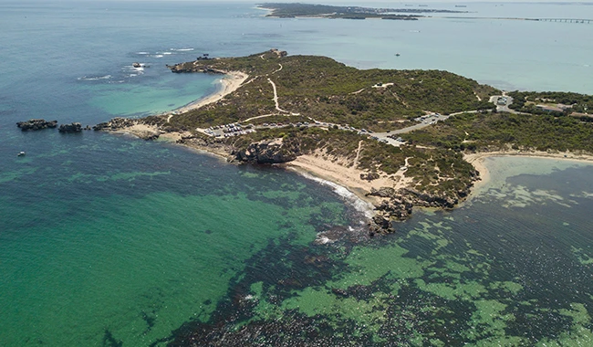
The Garden Island Highway is a partially constructed regional road which was originally intended to provide direct access to Cape Peron and HMAS Stirling as an extension of the broader road network. The majority of the Garden Island Highway is unconstructed with the full alignment being reserved in the Metropolitan Region Scheme (MRS) since 1975 for the purpose of accommodating the road.

Cape Peron was identified as a Planning Investigation Area (PIA) in 2018 after a proposal for a marina development at Mangles Bay was withdrawn by the Minister for Planning. A PIA is an area which requires further detailed planning to establish an appropriate range of land uses and compatible activities.
A Working Group, comprising representatives of State Government agencies and the City of Rockingham, and supported by a Community Reference Group, was established to consider:
- land tenure
- tourism opportunities
- tenure/lease management issues
- recreation and community needs and impacts
- environmental protection
- Aboriginal and historic heritage
- coastal setbacks
- regional roads
- bushfire risk.
The Cape Peron Working Group made nine recommendations that have been accepted by the Minister for Planning to be actioned. Recommendations 4 and 5 address transport needs and the Garden Island Highway
Recommendation 4. Garden Island Highway
The alignment and design of Garden Island Highway (identified as an Other Regional Roads reservation in the MRS) to be appropriately considered, in consultation with the Department of Defence, and cognisant of the environmental values of Cape Peron and Lake Richmond.
Recommendation 5. Transport needs
The City of Rockingham, in consultation with the Department of Planning, Lands and Heritage and the Department of Defence, is preparing a transport study that includes, but is not limited to:
- the local road network within Cape Peron and external connections
- improved pedestrian and cycle links
- the need for additional parking at key destinations
- potential impacts on the alignment of Point Peron Road.
The City prepared the Cape Peron Transport Needs Study to address Point 5.
Further information on the Cape Peron Implementation Committee can be found on the DPLH websiteopens in a new window.
The Study identifies recommended upgrades to the roads and pedestrian access to and within Cape Peron. It also addressed complementary matters such as additional visitor parking options within the Cape.
The Study also considered the broader transport implications of AUKUS, and the expansion of HMAS Stirling, on the key roads accessing Cape Peron. The Study outlines the projected impact of traffic up to the year 2040 and set outs recommended actions and responsibilities to address the projected impacts.
The City of Rockingham commissioned an independent expert consultant, Stantec, to prepare the Study. The City received inputs from Department of Defence, Main Roads WA and the Department of Planning, Lands and Heritage throughout the report's preparation.
Based on the projected traffic forecasts, significant congestion and queuing (greater than what is being experienced currently) is expected for Parkin Street, Point Peron Road and other local streets on the approach to Cape Peron and HMAS Stirling.
Without forming a view on if the Garden Island Highway can be built, the Study recommends that, in order to address the anticipated failings of the local road network, the Garden Island Highway be constructed by 2030.
To offer a temporary solution, the Study also recommends an upgrade to the intersection at Safety Bay Road/Parkin Street and Hymus Street/Point Peron Road into a new four-way roundabout.
No. The Study was not intended to provide a preferred design for the Garden Island Highway and it is expected that the subsequent processes, as detailed above, will consider and resolve design options.
That the state and/or federal governments fund and carry out the necessary feasibility study/investigation to confirm that the unconstructed portion of the Garden Island Highway can be built within the existing road reservation.
Also, that the federal government financially contribute to the upgrade of the intersection of Safety Bay Road/Parkin Street and Hymus Street/Point Peron Road and the westward extension of Point Peron Road to the entry of HMAS Stirling.
Like any project, all necessary approvals are required to be obtained including approvals under the state and federal environmental legislation and the Aboriginal Heritage legislation. The process being requested by the City will determine if the approvals can be achieved to build the Garden Island Highway.
A feasibility study is an encompassing term for a range of technical investigations to establish if the Garden Island Highway can be built within its reservation. As part of the study, it is expected that a preliminary road design will be prepared in order to assist in considering any potential impacts to the environment and surrounding development.
The preferred design should then be subject to a full environmental impact assessment under the Environmental Protection Act and Environmental Protection and Biodiversity Conservation Act.
It is the City’s expectation that the state and federal governments fund and manage all aspects of the feasibility study.
No. The Study only considered options that could be progressed within the established road reservations and did not address any subsequent implementation requirements.
In September 2021, Australia, the United Kingdom and the United States of America announced ‘AUKUS’, a new trilateral security partnership with the aim to enhance the stability of the Indo-Pacific region.
To facilitate the objectives of this partnership, the federal government is investing up to $8 billion to expand HMAS Stirling (also referred to as Fleet Base West) over the next decade to accommodate the acquisition and operation of conventionally-armed, nuclear-powered submarines. HMAS Stirling, the Royal Australian Navy’s largest naval base, is the City’s most significant local employer.
The first phase of AUKUS is focussed on a rotational presence at HMAS Stirling for one UK and up to four US, nuclear-powered submarines from 2027. This is known as the Submarine Rotational Force - West (SRF-West). The SRF-West will require the housing of up to 2,000 maintenance and support personnel. The United States will relocate personnel and their families to Western Australia from 2027.
The Metropolitan Region Scheme (MRS) defines the future use of land and provides the legal basis for planning in the Perth metropolitan region, dividing it into broad zones and reservations; this includes regional road reservations. It is administered by the Western Australian Planning Commission.
The Garden Island Highway is an unconstructed crown reserve dedicated for the purpose of a public road.
The unconstructed portion of the road reserve between Belgravia Terrace and Safety Bay Road is over land currently managed by the City. The portion of the Garden Island Highway within Cape Peron falls within the management of the Department of Biodiversity, Conservation and Attractions.